History of Earthquake's in Mexico

List of earthquakes in Mexico
Jump to navigationJump to search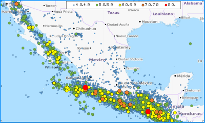 Map of earthquakes in Mexico from 1990 to 2017
This is a partial list of earthquakes in Mexico. This list considers every notable earthquake felt or with its epicenter within Mexico's current borders and maritime areas.
Contents
Geology[edit]
Mexico lies within two seismically active earthquake zones. The Baja California peninsula lies near the boundary of the Pacific Plate and the North American Plate, while southern Mexico lies just north of the boundary between the North American Plate and the Cocos and Rivera tectonic plates. The Cocos Plate is subducting under the North American Plate at a rate of 67 mm (0.220 ft) per year, while the Pacific and Rivera plates are moving northwest relative to the North American Plate. Southern Mexico also contains numerous faults, which causes that section of the country to have high tectonic activity. Northeastern Mexico and the Yucatan Peninsula are not as seismically active as the area close to the boundary between the North American and Cocos plates, but destructive earthquakes can still occur in those areas.
Earthquakes[edit]
Date Area Mag. MMI Deaths Injuries Total damage / notes
2020-06-23 Oaxaca 7.4 Mw VII 10 25
2018-02-16 Oaxaca 7.2 Mw VII 14 17 Most of casualties after a helicopter crash
2017-09-23 Oaxaca 6.1 Mw VII 6 7
2017-09-19 Mexico City, Morelos, Puebla 7.1 Mw VIII 370 6,011
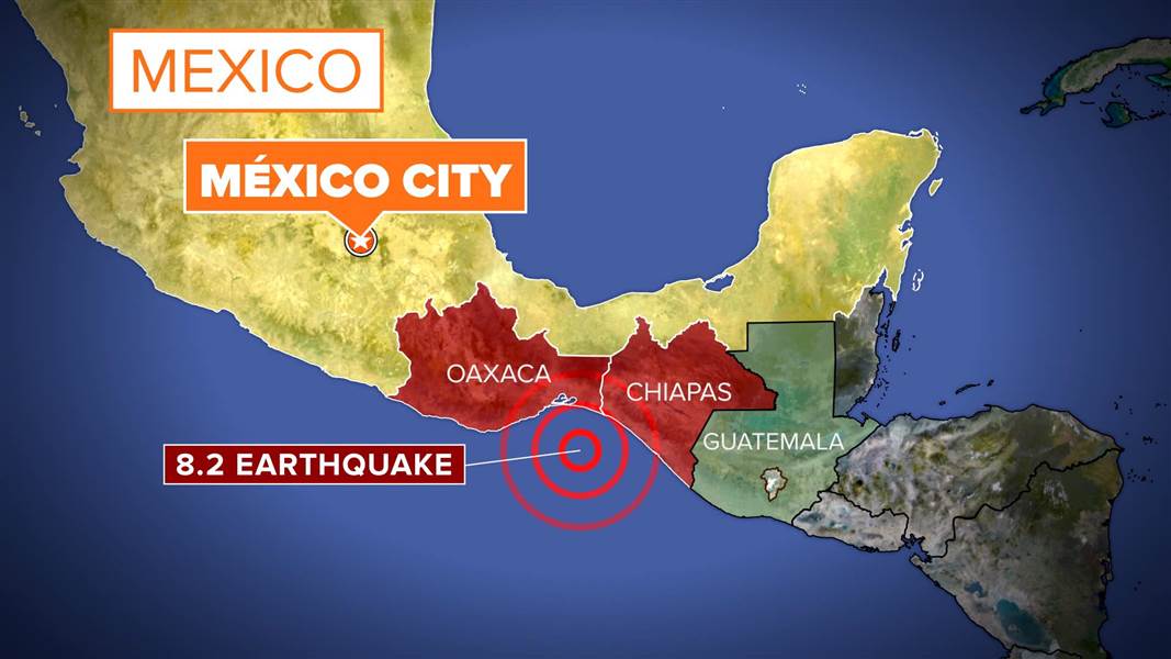
2017-09-07 Chiapas, Oaxaca 8.2 Mw IX 98 300 Tsunami
2015-10-23 Guerrero 5.5 Mw IV 2
2014-07-07 Chiapas 6.9 Mw VIII 5 12
2014-05-08 Guerrero 6.6 Mw VII
2014-04-18 Guerrero 7.2 Mw VII
1
2012-03-20 Guerrero, Oaxaca 7.4 Mw VII 2 11
2011-12-10 Guerrero 6.5 Mw VII 3 10
2011-05-05 Guerrero 5.7 Mw VI
2010-06-30 Oaxaca 6.2 Mw
1
2010-04-04 Baja California 7.2 Mw VII 2–4 100–233 $1.15 billion
2009-04-27 Guerrero 5.8 Mw V 2
2003-01-22 Colima 7.5 Mw VIII 29 300 Severe / tsunami
1999-09-30 Oaxaca 7.4 Mw VIII 35
1999-06-15 Puebla 7.0 Mw
20
MXN $200,000,000 [1] 1997-01-11 Michoacán 7.2 Mw VIII 1
Damage at Arteaga [2] 1995-10-21 Chiapas 7.1 Mw VI
1995-10-09 Colima, Jalisco 8.0 Mw VIII 49–58 100 Tsunami
1995-09-14 Guerrero 7.4 Mw VII 3
1985-09-19 Michoacán, Mexico City 8.0 Mw IX 5,000–45,000 30,000 Extreme / tsunami
1981-10-25 Michoacán 7.2 Mw
3
1980-10-24 Oaxaca 7.2 Mw IX 65–300+ Many $5 million
1979-10-15 Baja California 6.4 Mw IX
91
1979-03-14 Guerrero 7.6 Mw VIII 5 35
1973-08-28 Puebla, Veracruz 7.0 ML VIII 539–1,000 Thousands Severe
1973-01-30 Colima 7.5 Ms
56 390 Moderate / non-destructive tsunami NGDC 1968-08-02 Guerrero, Oaxaca 7.3 VII
1965-08-23 Oaxaca 7.5 Mw
6
1964-07-06 Guerrero 7.4 Ms IX 40
1957-07-28 Guerrero, Mexico City 7.9 Ms VII 54–160 Many Extreme / tsunami NGDC 1941-04-15 Colima 7.6 Mw IX 90
1937-07-26 Puebla, Veracruz 7.3 Ms IX 34
1932-06-22 Colima 7.0 Mw VIII
Tsunami
1932-06-18 Colima 7.8 Mw VIII
Tsunami
1932-06-03 Jalisco 8.1 Mw X 400
Tsunami
1931-01-15 Oaxaca 7.8 Mw X 114
1920-01-03 Puebla, Veracruz 7.8 Ms X–XII 648–4,000 167
NGDC 1912-11-19 State of Mexico 7.0[3] VIII
1911-12-16 Guerrero 7.6 IX
1911-06-07 Michoacán 7.6 IX 45
1909-07-30 Guerrero 7.6 IX
1907-04-15 Guerrero 7.7 VIII
1900-01-20 Colima 7.4 VII
1899-01-24 Guerrero 7.5 VII
1897-06-05 Oaxaca 7.4 VII
1894-11-02 Guerrero, Oaxaca 7.4 VIII
1892-02-24 Baja California 7.1–7.2 X 0
1890-12-02 Guerrero, Oaxaca 7.3 VII
1889-09-06 Guerrero 7.1 VI
1887-05-29 Guerrero 7.3 VIII
1887-05-03 Sonora 7.6 Mw
51
1882-07-19 Guerrero, Oaxaca 7.5 IX
1879-05-17 Puebla 7.1 VIII
1875-03-09 Colima, Jalisco 7.4 VII
1875-02-11 Jalisco 7.5 VIII
1874-03-16 Guerrero 7.3 VII
1872-03-27 Oaxaca 7.4 VI
1870-05-11 Oaxaca 7.8 IX
1864-10-03 Puebla, Veracruz 7.3 VIII
1858-06-19 Michoacán 7.5 IX
"Temblor de Santa Juliana" [4] 1854-05-05 Oaxaca 7.7 VIII
1845-04-07 Guerrero 7.9 Ms
"Temblor de Santa Teresa" [5][4] 1852-11-29 Baja California 6.5 MLa IX
[6] 1845-03-09 Oaxaca 7.5 VII
1837-11-22 Jalisco 7.7 IX
1835-01-06 State of Mexico
VII?
1820-05-04 Guerrero 7.6 VII
1818-05-31 Colima, Michoacán 7.7 VIII
1806-03-25 Colima, Michoacán 7.5 Ms
[5] 1800-03-08 Central, Eastern, and Southeastern
VII
1787-03-28 Guerrero, Oaxaca, Mexico City 8.6 Mw
Severe / tsunami
1776-04-21 Mexico City, Southern
VIII
Stover & Coffman 1993 uses various seismic scales. MLa is a local magnitude that is equivalent to ML (Richter magnitude scale) and is used for events that occurred prior to the instrumental period. It is based on the area of perceptibility (as presented on isoseismal maps). Mw = moment magnitude scale and Ms = surface wave magnitude. The inclusion criteria for adding events are based on WikiProject Earthquakes' notability guideline that was developed for stand alone articles. The principles described are also applicable to lists. In summary, only damaging, injurious, or deadly events should be recorded.

This is a partial list of earthquakes in Mexico. This list considers every notable earthquake felt or with its epicenter within Mexico's current borders and maritime areas.
Contents
Geology[edit]
Mexico lies within two seismically active earthquake zones. The Baja California peninsula lies near the boundary of the Pacific Plate and the North American Plate, while southern Mexico lies just north of the boundary between the North American Plate and the Cocos and Rivera tectonic plates. The Cocos Plate is subducting under the North American Plate at a rate of 67 mm (0.220 ft) per year, while the Pacific and Rivera plates are moving northwest relative to the North American Plate. Southern Mexico also contains numerous faults, which causes that section of the country to have high tectonic activity. Northeastern Mexico and the Yucatan Peninsula are not as seismically active as the area close to the boundary between the North American and Cocos plates, but destructive earthquakes can still occur in those areas.
Earthquakes[edit]
| Date | Area | Mag. | MMI | Deaths | Injuries | Total damage / notes | |
|---|---|---|---|---|---|---|---|
| 2020-06-23 | Oaxaca | 7.4 Mw | VII | 10 | 25 | ||
| 2018-02-16 | Oaxaca | 7.2 Mw | VII | 14 | 17 | Most of casualties after a helicopter crash | |
| 2017-09-23 | Oaxaca | 6.1 Mw | VII | 6 | 7 | ||
| 2017-09-19 | Mexico City, Morelos, Puebla | 7.1 Mw | VIII | 370 | 6,011 | ||
| 2017-09-07 | Chiapas, Oaxaca | 8.2 Mw | IX | 98 | 300 | Tsunami | |
| 2015-10-23 | Guerrero | 5.5 Mw | IV | 2 | |||
| 2014-07-07 | Chiapas | 6.9 Mw | VIII | 5 | 12 | ||
| 2014-05-08 | Guerrero | 6.6 Mw | VII | ||||
| 2014-04-18 | Guerrero | 7.2 Mw | VII | 1 | |||
| 2012-03-20 | Guerrero, Oaxaca | 7.4 Mw | VII | 2 | 11 | ||
| 2011-12-10 | Guerrero | 6.5 Mw | VII | 3 | 10 | ||
| 2011-05-05 | Guerrero | 5.7 Mw | VI | ||||
| 2010-06-30 | Oaxaca | 6.2 Mw | 1 | ||||
| 2010-04-04 | Baja California | 7.2 Mw | VII | 2–4 | 100–233 | $1.15 billion | |
| 2009-04-27 | Guerrero | 5.8 Mw | V | 2 | |||
| 2003-01-22 | Colima | 7.5 Mw | VIII | 29 | 300 | Severe / tsunami | |
| 1999-09-30 | Oaxaca | 7.4 Mw | VIII | 35 | |||
| 1999-06-15 | Puebla | 7.0 Mw | 20 | MXN $200,000,000 | [1] | ||
| 1997-01-11 | Michoacán | 7.2 Mw | VIII | 1 | Damage at Arteaga | [2] | |
| 1995-10-21 | Chiapas | 7.1 Mw | VI | ||||
| 1995-10-09 | Colima, Jalisco | 8.0 Mw | VIII | 49–58 | 100 | Tsunami | |
| 1995-09-14 | Guerrero | 7.4 Mw | VII | 3 | |||
| 1985-09-19 | Michoacán, Mexico City | 8.0 Mw | IX | 5,000–45,000 | 30,000 | Extreme / tsunami | |
| 1981-10-25 | Michoacán | 7.2 Mw | 3 | ||||
| 1980-10-24 | Oaxaca | 7.2 Mw | IX | 65–300+ | Many | $5 million | |
| 1979-10-15 | Baja California | 6.4 Mw | IX | 91 | |||
| 1979-03-14 | Guerrero | 7.6 Mw | VIII | 5 | 35 | ||
| 1973-08-28 | Puebla, Veracruz | 7.0 ML | VIII | 539–1,000 | Thousands | Severe | |
| 1973-01-30 | Colima | 7.5 Ms | 56 | 390 | Moderate / non-destructive tsunami | NGDC | |
| 1968-08-02 | Guerrero, Oaxaca | 7.3 | VII | ||||
| 1965-08-23 | Oaxaca | 7.5 Mw | 6 | ||||
| 1964-07-06 | Guerrero | 7.4 Ms | IX | 40 | |||
| 1957-07-28 | Guerrero, Mexico City | 7.9 Ms | VII | 54–160 | Many | Extreme / tsunami | NGDC |
| 1941-04-15 | Colima | 7.6 Mw | IX | 90 | |||
| 1937-07-26 | Puebla, Veracruz | 7.3 Ms | IX | 34 | |||
| 1932-06-22 | Colima | 7.0 Mw | VIII | Tsunami | |||
| 1932-06-18 | Colima | 7.8 Mw | VIII | Tsunami | |||
| 1932-06-03 | Jalisco | 8.1 Mw | X | 400 | Tsunami | ||
| 1931-01-15 | Oaxaca | 7.8 Mw | X | 114 | |||
| 1920-01-03 | Puebla, Veracruz | 7.8 Ms | X–XII | 648–4,000 | 167 | NGDC | |
| 1912-11-19 | State of Mexico | 7.0[3] | VIII | ||||
| 1911-12-16 | Guerrero | 7.6 | IX | ||||
| 1911-06-07 | Michoacán | 7.6 | IX | 45 | |||
| 1909-07-30 | Guerrero | 7.6 | IX | ||||
| 1907-04-15 | Guerrero | 7.7 | VIII | ||||
| 1900-01-20 | Colima | 7.4 | VII | ||||
| 1899-01-24 | Guerrero | 7.5 | VII | ||||
| 1897-06-05 | Oaxaca | 7.4 | VII | ||||
| 1894-11-02 | Guerrero, Oaxaca | 7.4 | VIII | ||||
| 1892-02-24 | Baja California | 7.1–7.2 | X | 0 | |||
| 1890-12-02 | Guerrero, Oaxaca | 7.3 | VII | ||||
| 1889-09-06 | Guerrero | 7.1 | VI | ||||
| 1887-05-29 | Guerrero | 7.3 | VIII | ||||
| 1887-05-03 | Sonora | 7.6 Mw | 51 | ||||
| 1882-07-19 | Guerrero, Oaxaca | 7.5 | IX | ||||
| 1879-05-17 | Puebla | 7.1 | VIII | ||||
| 1875-03-09 | Colima, Jalisco | 7.4 | VII | ||||
| 1875-02-11 | Jalisco | 7.5 | VIII | ||||
| 1874-03-16 | Guerrero | 7.3 | VII | ||||
| 1872-03-27 | Oaxaca | 7.4 | VI | ||||
| 1870-05-11 | Oaxaca | 7.8 | IX | ||||
| 1864-10-03 | Puebla, Veracruz | 7.3 | VIII | ||||
| 1858-06-19 | Michoacán | 7.5 | IX | "Temblor de Santa Juliana" | [4] | ||
| 1854-05-05 | Oaxaca | 7.7 | VIII | ||||
| 1845-04-07 | Guerrero | 7.9 Ms | "Temblor de Santa Teresa" | [5][4] | |||
| 1852-11-29 | Baja California | 6.5 MLa | IX | [6] | |||
| 1845-03-09 | Oaxaca | 7.5 | VII | ||||
| 1837-11-22 | Jalisco | 7.7 | IX | ||||
| 1835-01-06 | State of Mexico | VII? | |||||
| 1820-05-04 | Guerrero | 7.6 | VII | ||||
| 1818-05-31 | Colima, Michoacán | 7.7 | VIII | ||||
| 1806-03-25 | Colima, Michoacán | 7.5 Ms | [5] | ||||
| 1800-03-08 | Central, Eastern, and Southeastern | VII | |||||
| 1787-03-28 | Guerrero, Oaxaca, Mexico City | 8.6 Mw | Severe / tsunami | ||||
| 1776-04-21 | Mexico City, Southern | VIII | |||||
| Stover & Coffman 1993 uses various seismic scales. MLa is a local magnitude that is equivalent to ML (Richter magnitude scale) and is used for events that occurred prior to the instrumental period. It is based on the area of perceptibility (as presented on isoseismal maps). Mw = moment magnitude scale and Ms = surface wave magnitude. The inclusion criteria for adding events are based on WikiProject Earthquakes' notability guideline that was developed for stand alone articles. The principles described are also applicable to lists. In summary, only damaging, injurious, or deadly events should be recorded. | |||||||
